Recently in Telecomms & Internet Infrastructure Category

39 Furnival Street - entrance to Kingsway secret tunnels

|

London has lots of secret underground tunnels, dating from Victorian times, and especially from the World Wat 2 and Cold War eras.

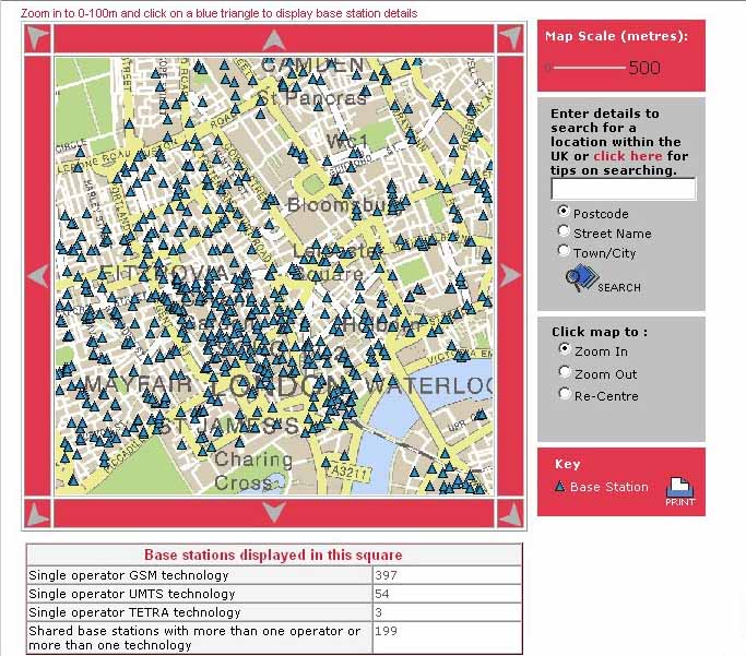
One of the main secret telecommunications and secret (relatively) bomb proof complexes is in the Kingsway area around Holborn.

MI6's secret tunnels - A deep, dark secret

Nov 24th 2008
From Economist.com

Snooker, piranhas and a hotline to Moscow

[...]

That might be why I have never noticed anything unusual about 39 Furnival Street. A brick building in a row of offices, its black double-doors are unmarked and unremarkable. But if you stop for a moment and look up, you might reconsider that judgment. Above the entrance is an industrial-size cast-iron pulley--odd in a street of legal firms. Above that, curiouser still: a wide, gaping air vent of the sort that you might see at the top of a mine-shaft.

What lies inside was once subject to the Official Secrets Act. But now this mysterious property is up for sale, and so I find myself with a few other journalists on the other side of the doors, signing consent forms and handing in my mobile phone (whose signal had mysteriously vanished as soon as I crossed the threshold). A lift takes us down 100 feet, deeper than the London Underground, which we can hear rumbling above us. A set of atom-bomb-proof doors are swung open and we step out into the secret of Furnival Street: the Kingsway tunnels, a miniature city beneath a city.

Dug in 1940 as London was blitzed by German bombers, the tunnels were designed as a air-raid shelter for up to 8,000 people, and as a possible last-ditch base for the government in the event of an invasion. They were never used as a shelter; instead, towards the end of the war they were taken over by the "Inter Services Research Bureau", a shady outfit that was in fact a front for the research and development arm of MI6 (perhaps better known as Q branch in the James Bond novels).

After the war, the tunnels were passed to the Post Office and then to British Telecom, which hopes to sell the warren for £5m now that it is surplus to requirements.

[...]

The tunnels--a mile of them in total, comprising two main drags and four smaller offshoots--have homely, superterranean-sounding names: South Street, Second Avenue and Tea Bar Alley. The illusion is only broken when you see behind the wood panelling the iron support structure, embossed with the initials of the London Passenger Transport Board, from whom parts of Tube tunnel were borrowed to build the complex.

The tunnels were still in secret use long after the Battle of Britain had given way to the Cold War. Deep under my bicycle route, technicians maintained the "hotline" between Eisenhower and Khrushchev, as well as a basic domestic network for Britain that would keep the country connected in the event of a major strike.

[...]

I spot an old circuit diagram on the wall, mapping out each of Britain's national newspapers. Were they being bugged back then? Probably. The question on my mind as we make our way back to the surface is: in which tunnel are the eavesdroppers hiding now?

Latitude: N51:31:02 (51.517191)
Longitude: W0:06:37 (-0.110373)

furnival_street_map.gif

39_Furnival_Street_from_Holborn_end_300.jpg

39 Furnival Street entrance to the Kingsway tunnels complex

Some more details can be found on Malcolm Bay's Kingsway Telephone Exchange website., including this diagram from Peter Laurie's 1979 book Beneath the city streets: A private enquiry into government preparations for national emergency

Kingsway_Telephone_Exchange_300.jpg

Kingsway Telephone Exchange diagram (click for a larger image). The Furnival Street Exit is marked as number 16 on the diagram, and the Prudential Building is number 7.

More photos:

Docklands - Harbour Exchange Square

|

As you travel on the Docklands Light Railway from the major Canary Wharf interchange south towards Greenwich, keep a look out for the nearby Harbour Exchange Square, which has several interesting buildings.

Harbour_Exchange_Square_map.gif

GPS grid coordinates:
Latitude: (WGS84) N51:29:56 ( 51.498976 )
Longitude: (WGS84) W0:00:53 ( -0.014769 )

The northern building (nearest to the Canary Wharf 1 Canada Square skyscraper)

Harbour_Exchange_Tower.jpg

Harbour Exchange Tower,
numbers 1 and 2 Harbour Exchange Square

used to house the United Kingdom Police's National High Tech Crime Unit, which has now been absorbed into the Serious Organised Crime Agency, which now no longer seems to give "new crimes, new technology" crimes like computer hacking or computer viruses or denial of service attacks any priority.

Incredibly the public internet website for this managed building still serves M$ Word document templates for various forms for things like

  • Tenants Fit Out Guide
  • Work Authority Certificates
  • Landlords Requirements of Contractors during Fitting Out Works
  • Minor Works Permit
  • Visitor Form
  • Removal of Equipment
  • Fire Evac Procedures
  • Actions to be taken by Fire Wardens
  • Emergency Evac Roll Call
  • Fire Precaution Details
  • Assembly Points Location Map
  • Layman’s Guide To Fire Systems

Which must make them vulnerable to thieves and spies who are willing to scribble an illegible signature at the bottom of a genuine security authorisation form.

Numbers 6 -7 and 8-9 house two separate Internet Data Centres, which are now owned by Telecity, and are linked to form part of the London Internet Exchange (LINX) system, through which most of the UK and Europe's transatlantic internet traffic flows.

Mobile Phones - Base Station transmitter masts in Central London

|

It is almost certain that any CyberPunk tourists to London will own one or more Mobile Phones.

Obviously these are now a core part of our modern communications society, but they are also increasingly being used for surveillance and snooping, by law enforcement and national security agencies, and by commercial vested interests, where they can get away with it.

GSM mobile phones (the vast majority, due to the relatively slow uptake of 3G PP
technology, the handsets for which in the UK are all also GSM capable) share out their government licensed radio frequency bands (900 Mhz and 1800 MHz for GSM and 2100MHz for 3G PP) by allocating a Network Provider, Base Station, Channel etc. "colours" " to each Mobile Phone Base Station transmitter, so that each "cell" around a particular transmitter does not interfere with its neighbouring cells.

In the sparsely populated open countryside or at sea, the cells cover approximately 35 kilometres (20 or so miles)

However within cities like London, the density of Base Stations and micro-cell transmitters is far greater than most people realise.

Here is an image published reluctantly by the UK Government agency which regulates the telecommunications and broadcasting industries and which allocates the radio frequency spectrum monopolies or licence free radio bands (such as it the 2.4GHz band used for WiFi and Bluetooth and some wireless CCTV cameras etc.). They deliberately make it hard to find from the front of their website and the data is out of date by up to 3 months, but it is still of interest: Ofcom Sitefinder website.


Mobile_Phone_Base_Station_masts_central_London_300.jpg

This map shows all the Mobile Phone Network Operators' Base Stations,- Vodafone, Orange, T-Mobile, O2,and Three - so any one individual phone will be handshaking with up to about a fifth of the total number in the area shown.

More on Location Based Services and Communications Traffic Data:mobile phone tracking:

Docklands Teleport - Satellite Earth Station

|

BT_Satellite_Teleport_300.jpg

The former British Telecom satellite earth station, with several large satellite uplink dishes in London Docklands was sold in March 2007 to become:

Docklands Teleport
Arqiva Satellite Media Solutions
Pier Road
North Woolwich
London E16 2JJ

The Nearest Tube station is "King George V" on Docklands Light railway (DLR).

Teleport_map.gif.gif

GPS grid coordinates:
Latitude: (WGS84) N51:29:59 ( 51.499709 )
Longitide: (WGS84) E0:03:47 ( 0.063067 )

The pop group Hard-Fi used this location for their 2007 music video Suburban Knights directed by Ben Crook, which has the band apparently breaking in to the satellite groundstation and "hacking" in to the system to broadcast their performance around the world, obviously unhampered by any security measures.

British Telecom Tower

|

The main visual landmark in central London between Oxford Street and the Euston Road is the British Telecom Tower, a microwave and fibre optic communications tower, which is central to London's telecommunications networks, and which sits between Cleveland Street and Howland Street and Maple Street (not open to the public)

Cleveland_Street_BT_Tower_1_300.jpg

BT_Tower_map.gif

GPS Coordinates:
Latitude: (WGS84) N51:31:17 ( 51.521487 )
Longitude: (WGS84) W0:08:20 ( -0.138852 )

Email Contact

email: blog @ CyberPunk [dot] org [dot] uk

Here is our PGP public encryption key or download it via a PGP Keyserver.

Hints and Tips for Whistleblowers

Please take the appropriate precautions if you are planning to blow the whistle on shadowy and powerful people in Government or commerce, and their dubious policies. The mainstream media and bloggers also need to take simple precautions to help preserve the anonymity of their sources e.g.

Zero history blog

Zero History blog - http://ZeroHistory.net

- documenting and analysing William Gibson's current novel in progress, with some London / UK locations already.

Spook Country blog

Spook Country blog - htpp://SpookCountry.co.uk

This documents and analyses William Gibson's novel Spook Country which has some London locations, and from which this London CyberPunk Tourist Guide was spawned.

Syndicate this site (XML):

Recent Comments

  • Memetic Engineer: BBC security correspondent Gordon Corera's magazine article prompted by the read more
  • Patrick: I started frequenting the Greyhound at the start of the read more
  • Memetic Engineer: @ A Genower - the dusty corridor and the old read more
  • Memetic Engineer: @ Saba - why is your cousin not applying for read more
  • Saba: hii i wonder if you can help me my uncel read more
  • Memetic Engineer: @ Nigel - from the Google Street View images, it read more
  • Nigel: Funny thing... if you visit Bywater Street in Google Maps read more
  • A Genower: I was a salesman for IBM office products (largely electric read more
  • me: http://maps.google.com/maps?f=q&source=s_q&hl=en&sll=50.830869,-0.147307&sspn=0.008349,0.016179&ie=UTF8&ll=51.498685,-0.140505&spn=0.009097,0.027251&z=16&layer=c&cbll=51.498602,-0.140564&panoid=a6ppV5N-mC2PeZ2sJuIxnQ&cbp=12,56.53,,0,25.21 read more
  • me: "On the original TV series the door colour was white" read more