Recently in Docklands Category

Docklands - Harbour Exchange Square

|

As you travel on the Docklands Light Railway from the major Canary Wharf interchange south towards Greenwich, keep a look out for the nearby Harbour Exchange Square, which has several interesting buildings.

Harbour_Exchange_Square_map.gif

GPS grid coordinates:
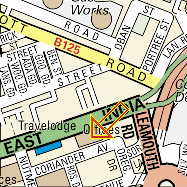
Latitude: (WGS84) N51:29:56 ( 51.498976 )
Longitude: (WGS84) W0:00:53 ( -0.014769 )

The northern building (nearest to the Canary Wharf 1 Canada Square skyscraper)

Harbour_Exchange_Tower.jpg

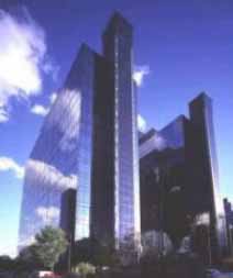
Harbour Exchange Tower,
numbers 1 and 2 Harbour Exchange Square

used to house the United Kingdom Police's National High Tech Crime Unit, which has now been absorbed into the Serious Organised Crime Agency, which now no longer seems to give "new crimes, new technology" crimes like computer hacking or computer viruses or denial of service attacks any priority.

Incredibly the public internet website for this managed building still serves M$ Word document templates for various forms for things like

  • Tenants Fit Out Guide
  • Work Authority Certificates
  • Landlords Requirements of Contractors during Fitting Out Works
  • Minor Works Permit
  • Visitor Form
  • Removal of Equipment
  • Fire Evac Procedures
  • Actions to be taken by Fire Wardens
  • Emergency Evac Roll Call
  • Fire Precaution Details
  • Assembly Points Location Map
  • Layman’s Guide To Fire Systems

Which must make them vulnerable to thieves and spies who are willing to scribble an illegible signature at the bottom of a genuine security authorisation form.

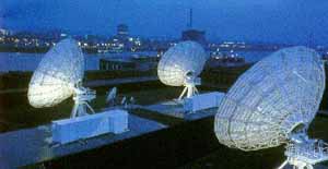
Numbers 6 -7 and 8-9 house two separate Internet Data Centres, which are now owned by Telecity, and are linked to form part of the London Internet Exchange (LINX) system, through which most of the UK and Europe's transatlantic internet traffic flows.

Docklands Teleport - Satellite Earth Station

|

BT_Satellite_Teleport_300.jpg

The former British Telecom satellite earth station, with several large satellite uplink dishes in London Docklands was sold in March 2007 to become:

Docklands Teleport
Arqiva Satellite Media Solutions
Pier Road
North Woolwich
London E16 2JJ

The Nearest Tube station is "King George V" on Docklands Light railway (DLR).

Teleport_map.gif.gif

GPS grid coordinates:
Latitude: (WGS84) N51:29:59 ( 51.499709 )
Longitide: (WGS84) E0:03:47 ( 0.063067 )

The pop group Hard-Fi used this location for their 2007 music video Suburban Knights directed by Ben Crook, which has the band apparently breaking in to the satellite groundstation and "hacking" in to the system to broadcast their performance around the world, obviously unhampered by any security measures.

Telehouse(s)

|

East of the City of London, lie formerly derelict London Docklands, where the Trade of the British Empire flowed to and from, in the days of break bulk cargo.

These have mostly been replaced by the Container Ports at Tilbury and at Felixstowe, situated further down the Thames river estuary, with access to deep water channels for the huge container ships.

The container port in Vancouver features in William Gibson's novel Spook Country

However, these former Docklands areas are being re-developed, and since 1990, they have housed the cyberspace telecommunications hubs, where most of the United Kingdom's and much of Europe's transatlantic Internet bandwidth flows via the London Internet Exchange - LINX and similar ventures.

Telehouse_North.jpg

Telehouse (now called Telehouse North)
Coriander Avenue,
London E14 2AA

Telehouse was designed and built in the late 1980's to house backup and disaster recovery mainframe computers for the financial district of the City of London some, 5 miles away to the west. It is linked to other data centres based in the new Dockland Canary Wharf development.

As the Internet took off in the UK, it ended up housing lots of Internet Service Providers and Web Hosting companies' routers and co-location server equipment as well, and its pioneering concept of a "computer hotel" and "co-location data centre", spread around the world.

This led to a second such Telehouse building (Telehouse East) being built next door.

Telehouse_map.gif.gif

GPS grid coordinates:
Latitude: (WGS84) N51:30:43 ( 51.512078 )
Longitude: (WGS84) W0:00:07 ( -0.002035 )

The fast cut music video for MTV friendly rock band Republica's world wide hit song "Ready to go" (1996), which has been used in several tv adverts movie soundtracks, sporting events etc. features the derelict industrial landscape of Docklands, with several shots of the lead singer Saffron with the original Telehouse building in the background.

See this Republika "Ready to Go" video on YouTube (needs Flash and Javascript)

Email Contact

email: blog @ CyberPunk [dot] org [dot] uk

Here is our PGP public encryption key or download it via a PGP Keyserver.

Hints and Tips for Whistleblowers

Please take the appropriate precautions if you are planning to blow the whistle on shadowy and powerful people in Government or commerce, and their dubious policies. The mainstream media and bloggers also need to take simple precautions to help preserve the anonymity of their sources e.g.

Zero history blog

Zero History blog - http://ZeroHistory.net

- documenting and analysing William Gibson's current novel in progress, with some London / UK locations already.

Spook Country blog

Spook Country blog - htpp://SpookCountry.co.uk

This documents and analyses William Gibson's novel Spook Country which has some London locations, and from which this London CyberPunk Tourist Guide was spawned.

Syndicate this site (XML):

Recent Comments

  • Memetic Engineer: BBC security correspondent Gordon Corera's magazine article prompted by the read more
  • Patrick: I started frequenting the Greyhound at the start of the read more
  • Memetic Engineer: @ A Genower - the dusty corridor and the old read more
  • Memetic Engineer: @ Saba - why is your cousin not applying for read more
  • Saba: hii i wonder if you can help me my uncel read more
  • Memetic Engineer: @ Nigel - from the Google Street View images, it read more
  • Nigel: Funny thing... if you visit Bywater Street in Google Maps read more
  • A Genower: I was a salesman for IBM office products (largely electric read more
  • me: http://maps.google.com/maps?f=q&source=s_q&hl=en&sll=50.830869,-0.147307&sspn=0.008349,0.016179&ie=UTF8&ll=51.498685,-0.140505&spn=0.009097,0.027251&z=16&layer=c&cbll=51.498602,-0.140564&panoid=a6ppV5N-mC2PeZ2sJuIxnQ&cbp=12,56.53,,0,25.21 read more
  • me: "On the original TV series the door colour was white" read more